Hidden in Marsh, Protected by Time
The Discovery of a Black Seminole Village in Lake County, Florida
By Shane Majors, ©2025
Writers Note: This article is composed of historical sketches that provide context for how this village came to exist; it’s a broadbrush of this interesting yet tumultuous time of Florida history. Though there are many perspectives to consider, this article aims to shed light not only on the discovery of a Black Seminole village but an oft overlooked narrative of how that village came to be through the experience of the Black Seminole, their origins, and their fight to live free. I am by no means an expert on the subject and at the end of this article I provided a list of resources if you wish to further explore this history of our state.
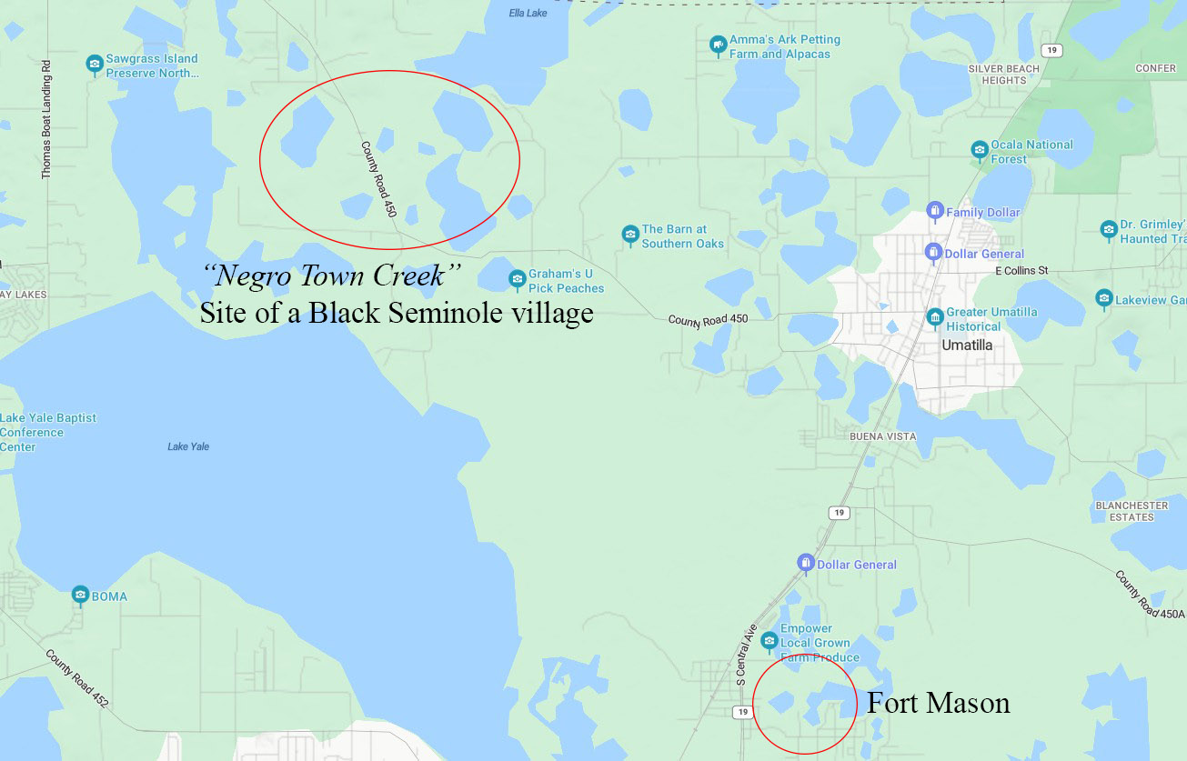
Each morning on my drive to work, I pass a sign that reads: “Welcome to Sumter County, Established 1853.” I never gave much thought to that date, except that it feels early for this part of Florida. I live not too far from that sign, in north Lake County, and it’s hard to imagine much of a past here. We’re surrounded by the Ocala National Forest to the north, marshlands to the south, and a nonstop sprawl of new construction in every direction – it doesn’t feel like a place with history, not the kind you can see, anyway. While researching for my post, The Ghost Town I Live In, I came across a document that challenged that view. In response to a question asking for the nearest creek or river east of a proposed post office, the respondent had listed “Negro Town Creek.” I paused, staring at my screen. Could there have been a Black community just a few miles from where I live? Before going any further, I needed to find context – its place and time.
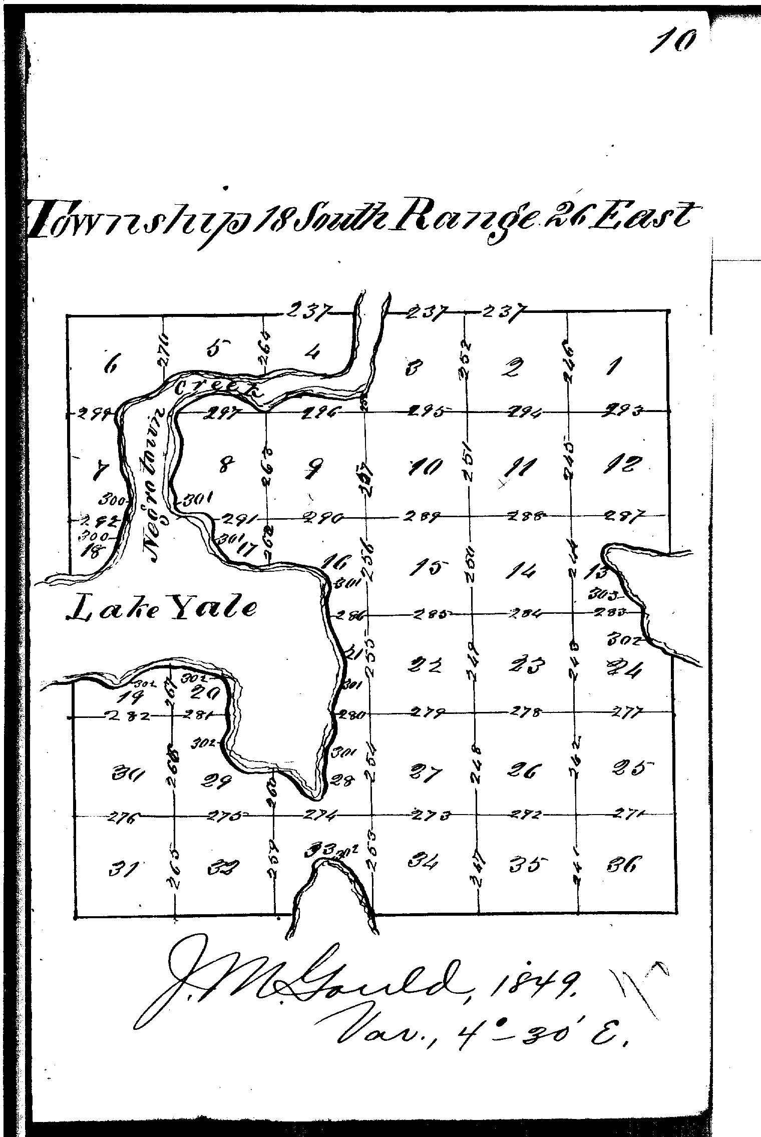
Florida’s landscape has changed dramatically over the past century. Development has altered its waterways, erased its trails, and buried its past beneath groves, roads, and neighborhoods. To better understand the terrain before these changes, I turned to an 1849 land survey and to my astonishment, the same marshland was labeled Negro Town Creek – sixteen years before the end of the Civil War. I needed to know more.
I found myself deep in archives, searching letters, diaries, maps, and forgotten manuscripts. I began finding names I didn’t recognize; real people who lived and resisted and belonged to this land in ways I never knew. Growing up in Florida, I learned about Seminole leaders like Osceola and Micanopy, but no one had ever told me about the Black Seminoles, or about figures like Abraham, a strategist and negotiator who helped lead their resistance. It was then I realized that the state I called home was, in many ways, a stranger to me – its deeper history hidden in the archives, footnotes, and, in this case, marshlands. I wanted to see if I could find what happened to this village, to its inhabitants. I wanted to find documentation.
But the more I read, the clearer it became this wasn’t just some ghost story I was chasing. It was a legacy of freedom fighters. Of survival. Of people building lives in a place where they weren’t supposed to be free but found ways to be anyway. I began to wonder if this long-forgotten village was part of a larger, powerful story; a community of free Black people who fought and survived in the shadows of Florida’s early wars.
Discovering Context: Spanish Florida and Maroon Communities
How do you find a town that has no name? With the location being the only certainty, I started on what was a seemingly hopeless endeavor. But I had to start somewhere. The most obvious was Fort Mason, the only contemporaneous establishment in the area. The fort was built during the Second Seminole War and was only a few miles from Negro Town Creek; my thought being that if I could find references to the fort, I could also find references to the town. But first I had to understand the context of how this village came into being. I needed to go back further to the European conquest of the Americas to when Florida was a Spanish territory.
It’s hard to imagine today, but the first tracks of the Underground Railroad led south – to Florida. Enslaved people fleeing bondage in the Carolinas and Georgia crossed the border into Spanish Florida, a movement that did not go unnoticed by either the Spanish or the British. As early as the 1600s, “Blacks were organizing themselves with their own leaders in militias…and began to provide military service to Spanish authorities” ¹. In 1693, King Charles II of Spain issued an edict granting freedom to all enslaved people who escaped to Florida and sought asylum, provided they converted to Catholicism. While the motives were disguised as altruistic – saving their souls – the real purpose was to weaken the British colonies by depriving them of labor while simultaneously strengthening Spanish defenses.
With the growing number of Black refugees entering Florida, Governor Manuel de Montiano established Gracia Real de Santa Teresa de Mose (Fort Mose, pronounced mo-say) in 1738, about two miles north of St. Augustine. This settlement became the first free Black community in what would later become the United States.² Not all who sought freedom lived at Fort Mose, however. Some settled within St. Augustine itself, while others chose more remote areas. The Spanish referred to these independent groups as cimarrón, a term later adapted by the British and Americans as “maroon.” These maroon communities often formed in isolated, marshy, or rugged terrain – landscapes that offered both protection and autonomy to those who called them home.
The edict only heightened British resentment and further inflamed tensions between the two powers, leading to a series of skirmishes along the borderlands. The conflict between England and Spain in the Florida arena ultimately concluded with the Treaty of Paris in 1763, which ceded Florida to the British. In response, the free Black inhabitants of Fort Mose, St. Augustine, and other settlements departed with the Spanish for Cuba, never to return, even after Spain regained control of Florida in 1783. The exact number of maroon communities that existed during this period remains unknown, as does the number of their members who joined the exodus to Cuba. What is clear, however, is that these communities continued to endure. Even under British occupation, the Underground Railroad persisted and continued into Florida, providing refuge – and new members – to those settlements of freedom seekers.
Si’maran: A Bond by Name and Experience
The term cimarrón has a complex and layered history. In Spanish, it originally referred to something “wild” or “untamed,” most often used to describe livestock that had escaped domestication. Yet the word itself was not Spanish in origin – it was adopted from the Taíno term si’maran, meaning wild, savage, or gone astray. Over time, cimarrón evolved beyond its agricultural roots and became a term used by the Spanish to describe people – those who escaped enslavement, as well as Indigenous communities who lived beyond colonial control3.
From this linguistic evolution emerged the word maroon, used throughout the Americas to describe autonomous communities of self-liberated Africans. The transformation of cimarrón did not end there, however. Within the Creek language, the term was adopted and pronounced as simaló-ni. This version, in turn, entered English as Seminole. The Americans used it broadly to refer to both the Indigenous populations of Florida and the Black inhabitants who lived among them. Consequently, labels such as “Negro Seminole,” “Black Indian,” and “Black Seminole” entered the historical record, though they often obscured the nuanced realities of identity and alliance within these intertwined communities.
The Seminole Nation itself emerged from a process of fragmentation and reformation. It was composed primarily of Creek dissidents disillusioned with the Creek Nation, along with members of the Yamasee, Apalachee, Yuchi, and Hitchiti peoples4. Parallel to this development, maroon communities established settlements alongside Seminole villages. One of the largest, Pilaklikaha (founded in 1813 near present-day Center Hill), became a thriving center of Black life and native alliance.
Black Seminoles became vital in negotiations with Whites as they understood the language and culture, as a result Black Seminole leaders became an integral part of the Seminole community. Some Seminole leaders held enslaved individuals, but the institution differed greatly from the chattel slavery practiced by Europeans and Americans. It more closely resembled a feudal system in which they lived independently, cultivating their own fields while contributing a portion of their harvest and cattle as tribute to a chief. This interdependent relationship, born of necessity and mutual respect, strengthened over time – especially as the loss of Spain as an ally left both groups increasingly vulnerable.
Together, Seminole and maroon communities resisted American expansion, culminating in a series of conflicts collectively known as the Seminole Wars. These wars, spanning decades, were not merely struggles over land but battles for autonomy, identity, and survival5. It is within this historical context that the settlement once located in northern Lake County emerged – a community whose story, partially obscured by time, begins to resurface through records of the Second Seminole War.
Second Seminole War
Like any major conflict, the circumstances were lain in the decades before. The Treaty of Moultrie Creek, signed on September 18, 1823, formally established a Seminole reservation in much of Central Florida, including all modern-day Lake County. The location effectively cut them off from either coast, thus diminishing trading, creating an isolating environment, and forcing them to inhabit land that was of poor quality. The intention was of course to make their lives difficult so they would be persuaded to leave. In 1830 the Indian Removal Act was signed into law thus negating any previous treaties between the indigenous populations and the United States; the objective was the forced removal of all tribes to the west of the Mississippi to Oklahoma territory. This, on top of the dissolution of the Treaty of Moultrie Creek as well as the pressure of encroaching settlers ignited what would become the costliest of the Indian wars – the Second Seminole War.
Reading the letters of Major General Thomas Jesup who oversaw the Florida campaign from 1836 to 1838, I gained an insight into the dynamics of the Seminole and Black Seminole relationship. In the beginning, the aim of the United States was to send the natives to Oklahoma and sell the Black population into the plantation system. Jesup was one of the first to realize that wasn’t going to be possible. Found in the Congressional Court of Inquiry records, he penned a letter to the Secretary of War where he states quite candidly,
“…[chiefs] Micanopy, Philip, and Cooper, who are about a day’s march from each other, each with from one hundred and twenty to two hundred Indian and negro warriors – the latter, perhaps, the more numerous….This, you may be assured is a negro, not an Indian war, and if it not be speedily put down, the south will feel the effects of it on their slave population before the end of the next season.” 6

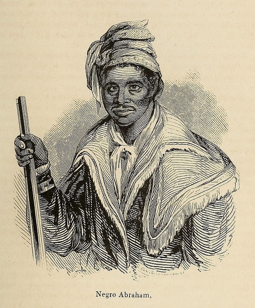
advisor to Micanopy. Open source image.
Abraham, Chief Micanopy’s trusted advisor and interpreter, was among the most senior of the Black leaders during the conflict. Contemporary accounts describe him as “cunning,” “intelligent,” and “shrewd,” qualities that made him a formidable negotiator7. A former slave and soldier, Abraham appeared to possess a deeper understanding of the American military system – and of what was at stake for the Black community should the war be lost. He therefore advocated for migration to the West. This position, however, earned him many enemies among both the Seminole and Black Seminole communities. Many warriors were resolved to die defending their land rather than leave it, not fully grasping the vastly different consequences that awaited a captured Seminole warrior compared to a captured Black warrior. Abraham, able to view the conflict from a broader perspective, worked alongside General Jesup and played a crucial role in securing the inclusion of Article 5 in the 1837 treaty, which stated:
“…the Seminoles, and their allies, who come in, and emigrate to the West, shall be secure in their lives and property; that their negroes, their bona fide property, shall accompany them to the West…”8
Though his efforts brought him many enemies, Abraham helped defy the motives of the war and by the end, over 500 Black Seminoles were transported to Oklahoma and to freedom. He and his family made their way in 1839, but Abraham continued service with the government as an interpreter into the 1850’s. His commitment to his people can be felt in his statement to Jesup,
“We do not live for ourselves only, but for our wives & children who are as dear to us as those of any other men…I have done all I can, my heart has been true since I came in… All Seminole Brethren are coming in… all the Black people are contented, I hope.”9
Life in Oklahoma came with its own complexities – fighting for autonomy from the Creek Nation while simultaneously seeking recognition within the Seminole Nation. Both the United States government and the Creeks regarded the Seminoles as a subset of the Creek Nation, subject to Creek laws, a view that deepened divisions between the groups. The Creeks, moreover, practiced slavery in ways that mirrored the American South, further straining relations. In 1856, a treaty between the Seminoles, Creeks, and the United States formally established the Seminole Nation in Indian Territory. Yet for the Black Seminoles who had fought, suffered, and migrated alongside their Native allies, this new beginning came with a painful irony – they were increasingly treated as outsiders within their own communities. Many eventually separated into independent bands, forming settlements in Texas and across the border in Mexico. Questions of identity – of blood and lineage – would continue to complicate their relationship with the Seminole Nation, reverberating well into the present. 10

“Ocklawaha Swamp” (Lake Griffin).
Source: National Archives (103396650)
Source: State Archives of Florida, Florida Memory (323228)
Source: National Archives (103396653)
Even in 1843 Lake Yale and Lake Harris are still not documented.
Source: State Archives of Florida, Florida Memory (323197)
Searching For Evidence
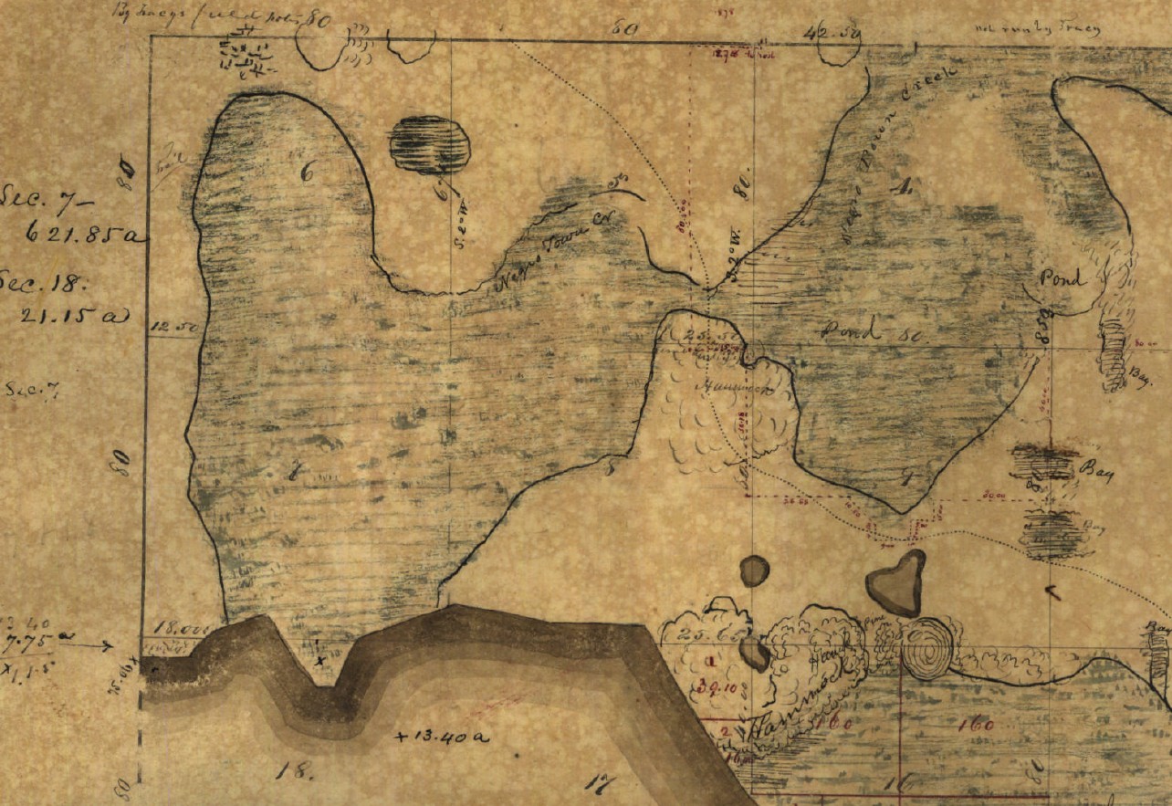
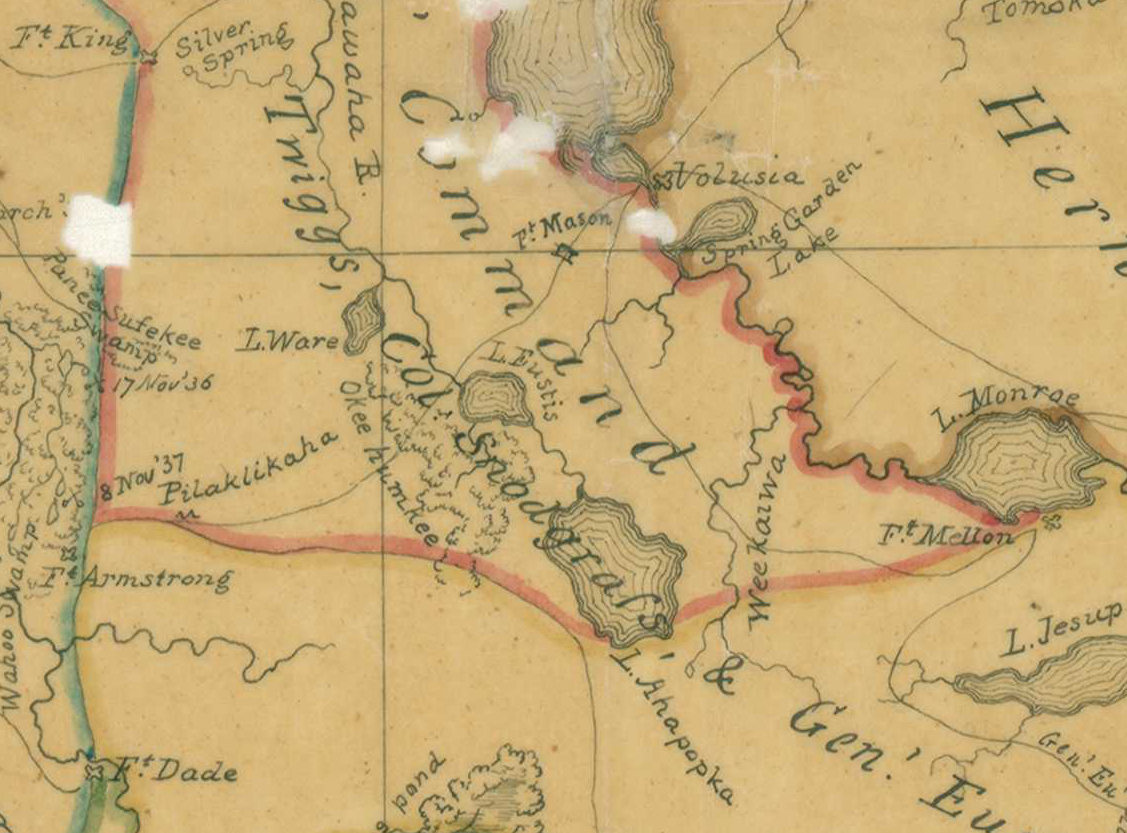
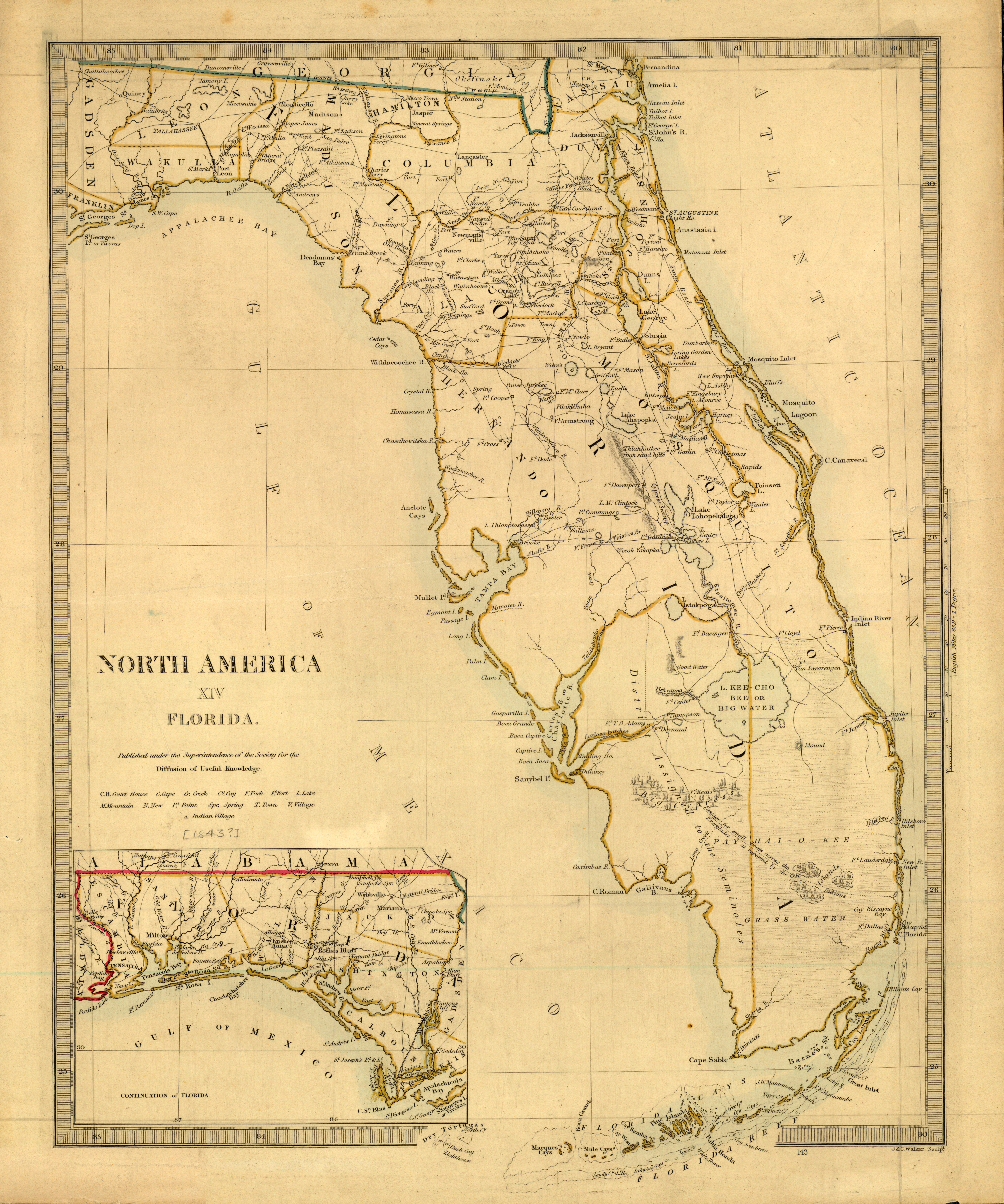
Finding references to a town with no name with a link to Fort Mason in 1836 proved fruitless. Doubt surrounds the accuracy of the roadside plaque that claims to know when and by whom the fort was built, and in my own research, I too began to discount its reliability.11 So where to look next? I started close to home, searching the collections at the Orange County Regional History Center, where I found several maps related to the Second Seminole War that seemed promising. After reaching out, I was contacted by a historian from the Center who shared links to the relevant materials. One of these maps was created by John Lee Williams, who, in 1837, published The Territory of Florida. His map identified a number of Indian villages and so-called “Negro Towns,” but none in the area I was investigating. It seemed the more I searched, the more it illuded me; like one of the maroon communities protected by the marshes, this village was protected by almost two hundred years of history.
I then turned to the National Archives and searched the maps that were created during the Second Seminole War hoping to find more details on the locations of villages but found only redundant information. However, the lead of John Lee Williams and his book The Territory of Florida ended up being the key; shortly after its first publication he began work on a revised second edition that was never published. Luckily, the P. K. Yonge Library at the University of Florida has the manuscript in their special collections and after days of eye-crossing research, there on page 265, he records a rather small excerpt of an event,
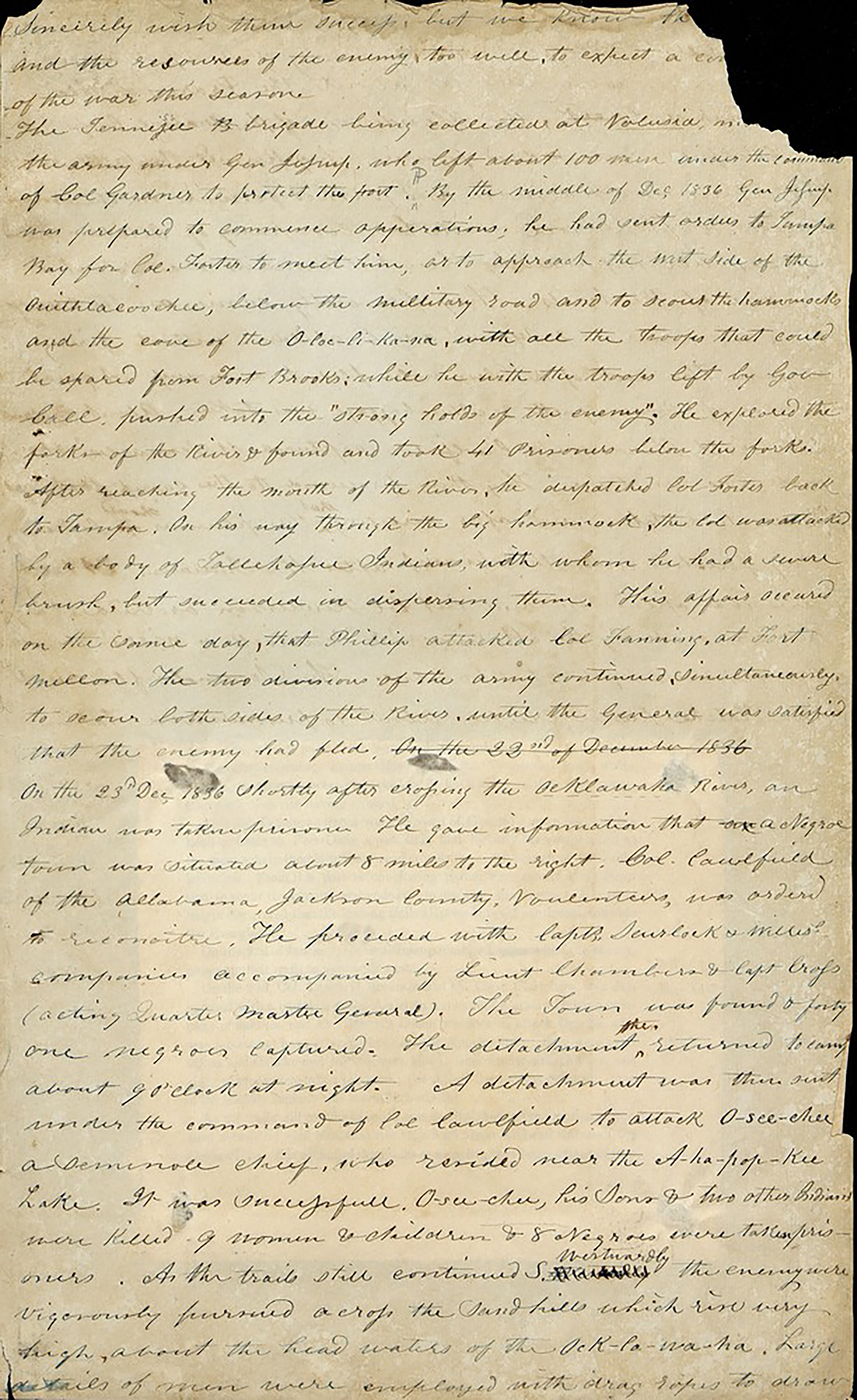
“On the 23rdDec 1836 shortly after crossing the Ocklawaha River an Indian was taken prisoner. He gave information that a Negro town was situated about 8 miles to the right. Colonel Caulfield…was ordered to reconnoiter…The town was found 41 negros captured the attachment returned to camp about 9:00 at night.”12
The description of the location seemed to align with the area I had in mind, and I couldn’t help but wonder, could this be it? If Williams had recorded it, I reasoned, then surely it must have been documented elsewhere. I had looked into Major General Thomas Jesup’s records several times before, but during this last search, I came across a press release announcing that his diary had been digitized and made available through the Florida Memory Project’s website. On the diary’s homepage was a list of events – and there, transcribed in his own words, was the very entry I had been hoping to find,
“3. [December 1836] went forward, crossed the Ocklawaha at the lower end of a lake on a temporary bridge constructed by General Eustis [emphasis added]– Soon after captured an Indian from whom information was obtained of the situation of a negro village at the head of the lake [emphasis added]. Detached Lt. Caulfield with two companies of his battalion, accompanied by Capt. Crossman and Lieut. Chambers, also by an interpreter and the Indian prisoner – Genl. J. Moved forward with the remainder of the command about five miles encamped on a beautiful lake – Lieut. Col. Caulfield returned about 9 p.m. with forty-one negro prisoners, having surprised the village, captured the greater part of its inhabitants, and burnt the houses and property which they could not bring in.”13
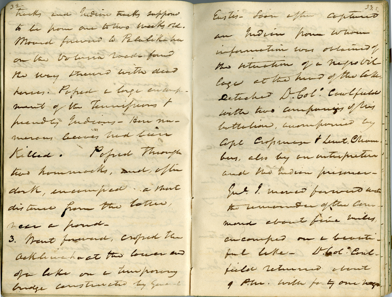
Source: Thomas Sidney Jesup Diary, 1836-1837 (page 18). The State Archives of Florida, Florida Memory.
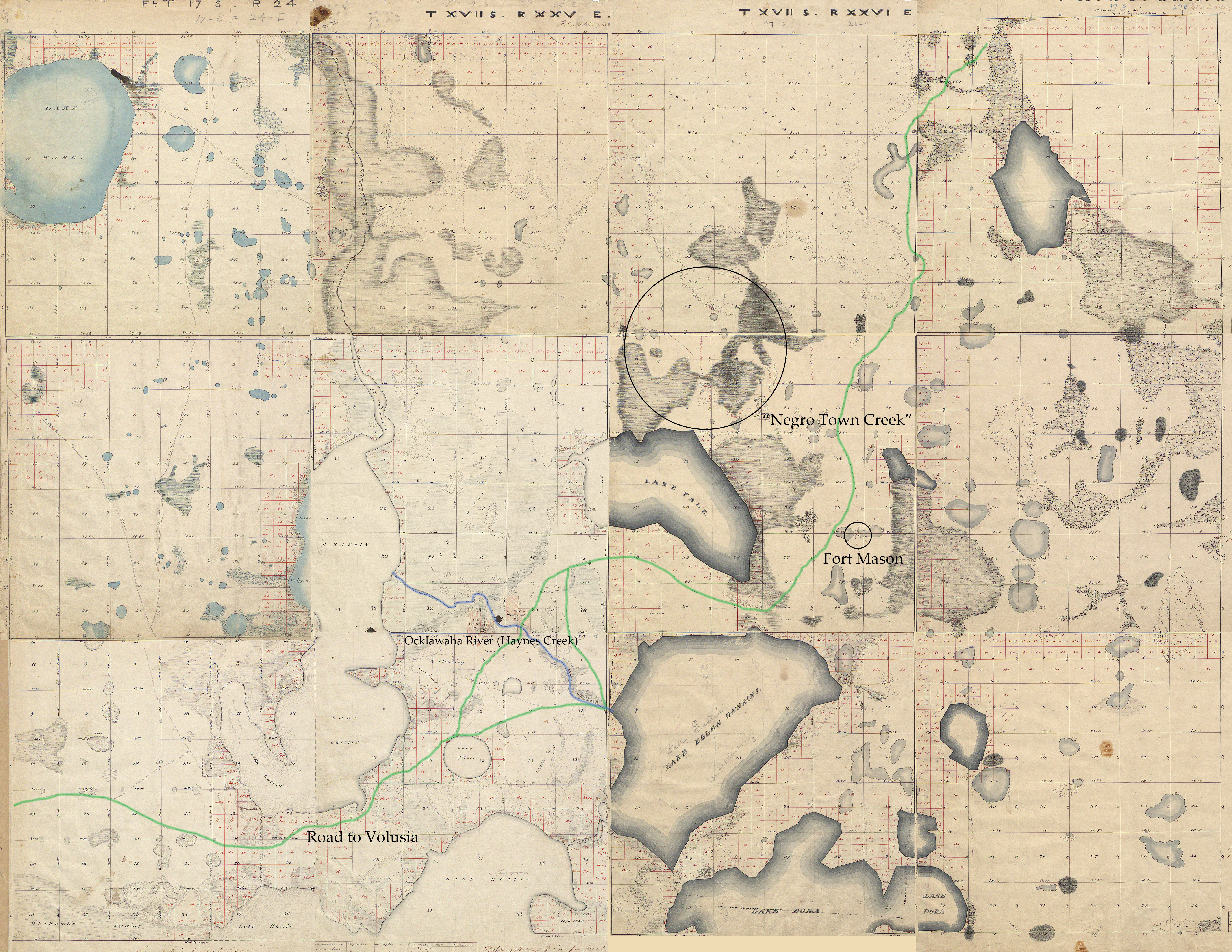
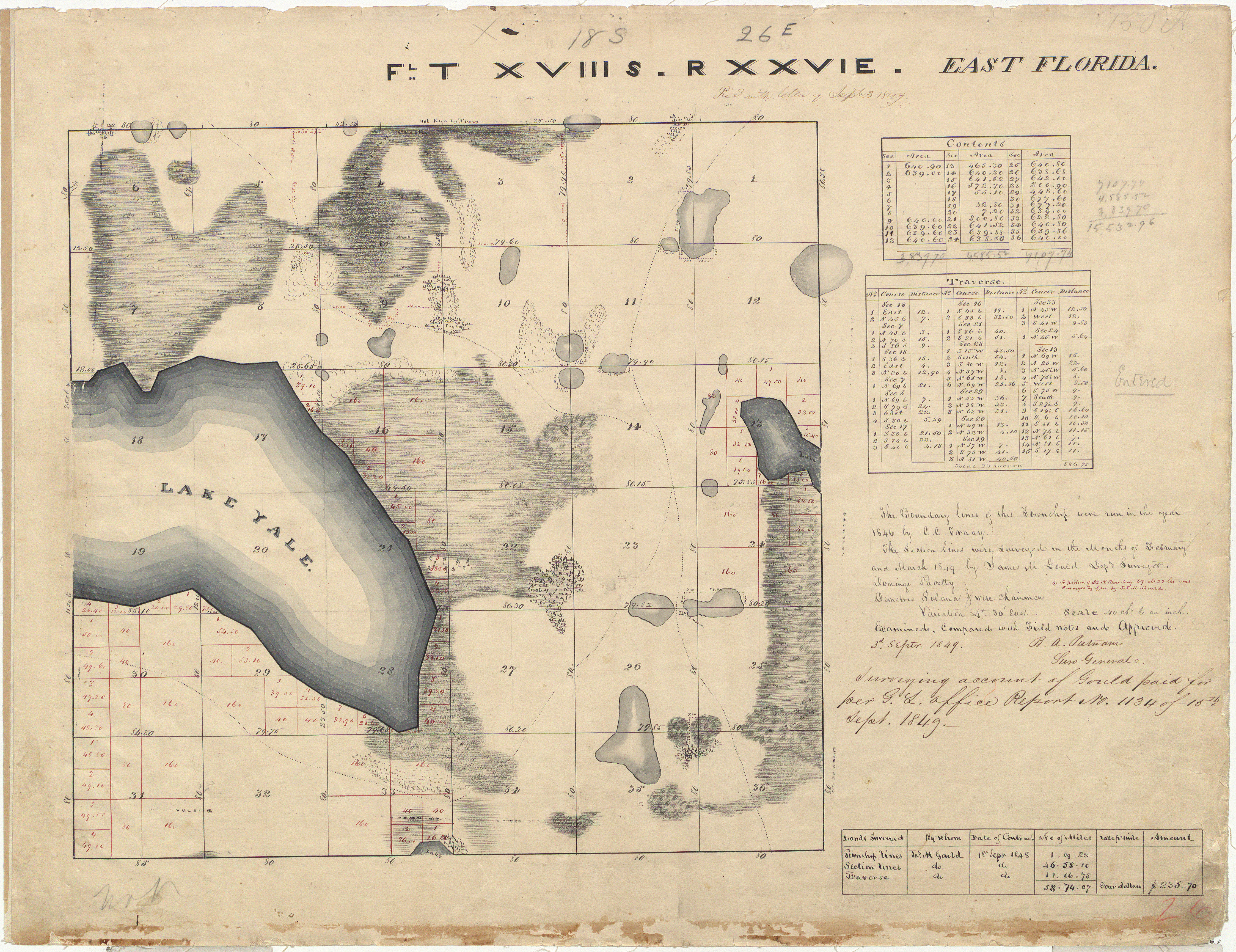
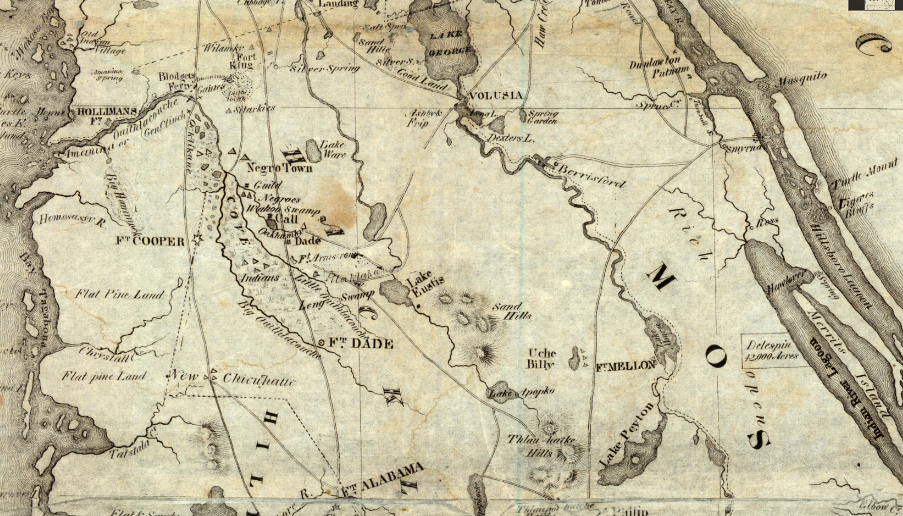
When I first read this passage, I felt disheartened – not only by the event itself, but also because the description didn’t quite align with the location I had imagined. Determined to solve this, I returned to Jesup’s diary. The previous entries noted that he had been in Pilaklikaha (near present-day Center Hill) and was traveling to Volusia. To better visualize his route, I created a collage of the 1849/1850 land surveys of the region, hoping to reconstruct as accurate a picture of the terrain as possible. I then compared this with the war maps from the period, including one from 1836 depicting General Eustis’s route, specifically marking Eustis Upper Ford. The road to Volusia ran south of Lake Griffin, but I was confused by Jesup’s reference to the Ocklawaha River. As I studied my collage and traced the old roads, I realized that the creek I cross every day on my way to work – Haynes Creek – was also once known as the Ocklawaha River. It was all beginning to make sense. In his official report to the Secretary of War, Jesup writes,
“On the 3rdinstant my spy company succeeded in capturing an Indian near the Ocklawaha river, from whom I received information of the situation of a village, inhabited by negros, on the lake in which the river has its source, I detached Lieutenant Colonel Cawfield, of the Alabama twelve months’ volunteers, with orders to burn the village and capture or destroy its inhabitants. The result of the expedition was the destruction of the village and the capture of forty-one negros. The service was performed in the most prompt and handsome manner.”14
The war maps from this period are notoriously inaccurate, leaving out several nearby lakes including Lake Yale and Lake Harris. Lake Yale lies parallel to Lake Griffin – the historical source of the Ocklawaha – and I suspect that Jesup may have confused the two. In fact, even the land surveys reveal that the surveyors had mislabeled the lakes. When Jesup’s diary entry is read in the context of Lake Yale – the area where the town was located – the description aligns perfectly; he noted being at the lower end of the lake, and the town at its head. Moreover, the distance mentioned by John Lee Williams also matches; if you rotate the collage to match the orientation of the war maps, the stretch from Haynes Creek/ Ocklawaha River to the village is roughly “eight miles to the right”. My jaw dropped as I realized that everything finally fit – the references, the geography, the documents. I had found the evidence I had been searching for.
Its destruction by fire mirrored that of other Seminole and Black Seminole villages. But what became of its inhabitants, the people who were taken prisoners? Jesup’s diary offers the first clues. He records that he transported the captives with his troops to Volusia, where, on December 6th, his aide, Lieutenant J. A. Chambers, was “employed in examining the prisoners.”15 In a letter dated December 9th, Jesup wrote to William Schley, then governor of Georgia:
“By a fortunate capture of an Indian and about forty negros, on the 3rd instant, I have obtained a knowledge of the positions of the several chiefs, blacks[?], and us[?] with their followers…”16
It’s evident that those captured were interrogated for intelligence. In a subsequent letter dated December 18th, Jesup reported that the prisoners disclosed that Micanopy, Jumper, and Abraham were attempting to avoid engagement by hiding in dense swamps and hammocks, and that Osceola “will never surrender.”17 Writing on December 9th to George McDuffie, governor of South Carolina, he asserted:
“It is highly important to the South that this war be put down promptly, it is a Negro war, not an Indian war – there are in Florida, I have good reason to believe four regularly organized Negro companies, exceeding two hundred and sixty warriors…I have already by detachment, destroyed one Negro town and taken about forty prisoners and I consider it more important to destroy or capture them than the Indians…”18
Jesup would state several times later that the “negros rule the Indians”19 and he reiterated this belief to McDuffie that the real battle was with the free Black population of Florida, and their death or capture were paramount to winning the war. Yet as the campaign unfolded, Jesup came to recognize that the two communities could not be disentangled. Any attempt to compel Seminole compliance would require provisions for their Black allies. It is here, however, where the documentary record falls silent. Beyond these letters, the story of this community and the people who inhabited it disappears from the archives, leaving only speculation; were they sold into slavery, or deported to Indian Territory?
Ballard’s Field
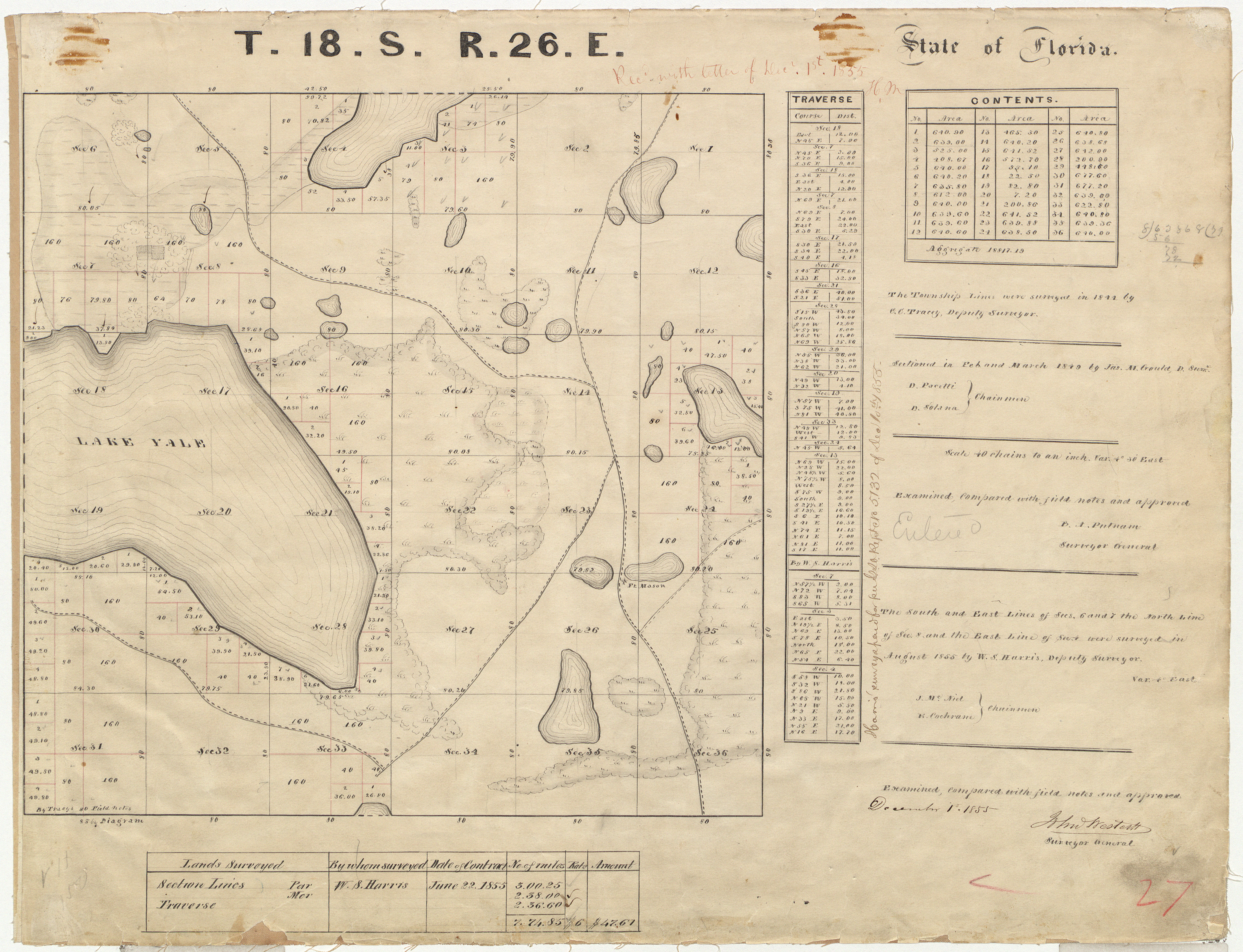
After I had exhausted the resources at the Orange County Regional History Center, my search was forwarded to historian Stewart Dunaway, who offered valuable insight into the Second Seminole War. In reviewing the 1855 land survey of the area where the village had once been located, he noticed something peculiar – a field situated within a hammock. At first glance, that might not seem unusual, yet the absence of the emblem indicating a dwelling or settlement was striking. The initial assumption was that it might have been an abandoned Indian field. However, when I examined the surveyor’s field notes, the site was recorded as “W Ballard’s field.”20 Who was W. Ballard?
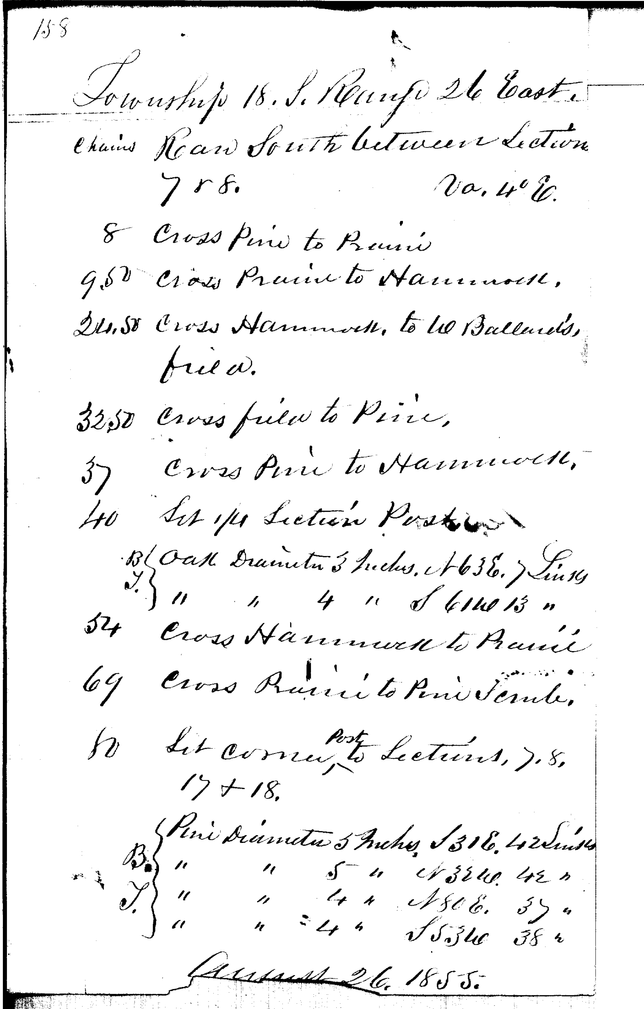
The Armed Occupation Act of 1842 was a federal initiative designed to encourage settlement in central and southern Florida by offering 160 acres to anyone who could establish a dwelling and cultivate at least five acres within five years with some of the most sought-after tracts being former Indian fields, hammocks, and fertile river valleys.21 Often it was a family affair with multiple generations applying for grants, and it seems to be the case with the Ballard’s. Lewis Ballard along with his sons James Clark, Alvin and William L. migrated from Franklin County, Georgia and applied for and received land in Marion County near present day Ocala.22 James Clark Ballard had settled in the area with his parents and brothers in 1843 as a bachelor23 and on December 5 of the following year, he married Adaline Drew Beal24.
Through the Land Boundary Information System (LABINS), I located a map that documented the sale history of the Marion County portion of Negro Town Creek. Noted within Township 17 South, Range 26 East, Section 33 was “Jas. [James] C. Ballard,” situated roughly two miles north of the field but within the area encompassing the creek.25 The receipt number listed on the map corresponded to an entry in the State of Florida Tract Books, which recorded the effective date of the deed as June 26, 1856.26 However, the 1855 survey suggests that Ballard and his family were already residing there by that time. As with the move from Georgia, it appears that the mysterious “W Ballard” must have been his brother William. What prompted their move from Ocala remains unclear, but the records indicate that James and his family eventually settled in this area and, by 1868, had established a homestead just north of Eustis, Florida.27
But what about William? His actions raise more questions than there are answers. The 1849 land survey recorded only the perimeter of the hammock and swamp, and it wasn’t until 1855 that the interior was more fully explored, leaving the origins of the field’s existence uncertain.28 Officially, the last recorded use of the name “Negro Town Creek” appeared in 1849, yet it persisted in local vernacular into the early twentieth century, appearing as late as 1912 in an Ocala Banner article about the construction of a railroad. When James, William and other settlers arrived in the area, they must have been aware of its recent history. This raises several questions: did they encounter the overgrown, charred remains of a former village and the vestige of a field waiting to be reclaimed? It’s curious that William didn’t hold the grant for a parcel he claimed. Was he a squatter waiting for the opportunity to possess it as his own? Whatever his motives, it didn’t work; the land never became his. In 1856, three deeds were granted to John L. Peers “Trustee for C. A. Peers,” and two of them included the field. Eventually, the site was purchased by a citrus packing company, and today the area where the field once lay remains an open space.29 It’s an intriguing thought to consider that perhaps this could point to the village’s original location.
Conclusion
Now, when I pass the roadside signs welcoming me to the towns and counties of Central Florida, I no longer see just a date – I see the weight it bears; the struggle, the pain, and the bloodshed that defined the years before. Spanish Florida once represented the promise of freedom, a refuge for those who escaped enslavement. Spain not only extended protection to the self-liberated but the isolated landscape and natural defenses provided security for the maroon communities that took root here. Within this environment, Seminole and Black Seminole peoples forged symbiotic relationships grounded in a shared pursuit of autonomy amid the looming threat of American expansion. These settlements offered more than shelter – they were spaces of belonging, identity, and resistance.
The settlement once located in what is now Lake County may well have been among these havens. As expansionist pressures intensified, Black Seminoles stood alongside the Seminoles in defense of their freedom and lands. Yet while many continued to fight, leaders such as Abraham perceived the conflict through a broader lens; recognizing that, should they lose, his people would face enslavement once more. His collaboration with Major General Thomas Jesup proved instrumental in securing freedom for hundreds. Though the village’s destruction may have marked the end of the Black freedom fighters in Florida, their legacy endures – one that should not vanish into the same ashes that consumed their homes.
As Lake and other counties prepare to memorialize someone whose life bears no real connection to its history, I hope this article can serve as a reminder that there are legacies far more worthy of remembrance – legacies that transcend shortsighted political gestures. We should honor those who resisted oppression, who chose freedom over enslavement, not those who sow division and hate.
And as I began uncovering the history of the place I call home, I realized I wasn’t just reading dates and names, I was stepping into countless worlds layered atop one another. Beginning as a simple weekend project it evolved into three years of discovery – tracing the story of a once-thriving citrus boomtown that vanished into the very groves it helped promote, and uncovering, along the way, the traces of a forgotten Black Seminole village. Many realities, many souls have passed through here; walking the same ground but under different skies. In my search, there were moments I felt guided –perhaps by divine hands, perhaps by the ghosts of this community; maybe the two are one and the same. Somehow, I’ve been entrusted to tell the story of this hidden village, a story that has remained veiled from the world for so long, guarded from the prying eyes of history.
“Genl J. stipulated on the part of the United States that the Seminoles should be secure in their persons & property- that their negroes shall accompany them West of the Mississippi … “
Source: Thomas Sidney Jesup Diary, 1836-1837 (page 67). State Archives
of Florida, Florida Memory.
Further Reading
As I mentioned in the beginning of this article, here is a reading list that will provide more details about the times and experiences that I was not able to cover here.
Florida’s Negro War: Black Seminoles and the Second Seminole War 1835-1842. By Anthony E. Dixon
The Negro Abraham by Kenneth Wiggins Porter. http://seminolenation-indianterritory.org/negroabraham.htm
Living in Oklahoma was still fraught with struggle and the fight to be free and be seen as an equal in the Seminole tribe. The following article sheds some light on their continued endeavor. The History of Black Seminole Indians: From Florida to Mexico. Texas State Historical Association. By Tracé Etienne-Gray https://www.tshaonline.org/handbook/entries/black-seminole-indians
The Black Seminoles of Florida: A Wanting Narrative is a presentation I gave to the Society of American Archivists Students and New Archival Professionals (SNAP) group on the theme of Records of Resistance. https://drawing-with-scissors.com/resistance/
Sources for this article:
1. Anthony E. Dixon, Florida’s Negro War: Black Seminoles and the Second Seminole War 1835-1842 (AHRA Publishing Division, 2023) P. 32.
2. “The Fort Mose Story,” Fort Mose Historical Society, Accessed 23 Aug 2025
https://fortmose.org/about-fort-mose/.
3. “Collision of Worlds,” Seminole Tribe of Florida, Accessed 20 Sep 2025,
https://www.semtribe.com/history/CollisionofWorlds.
4. Anthony E. Dixon, Florida’s Negro War: Black Seminoles and the Second Seminole War 1835-1842 (AHRA Publishing Division, 2023) P. 36.
5. The Long War,” Seminole Tribe of Florida, Accessed 20 Sep 2025,
https://www.semtribe.com/history/the-long-war.
6. Govinfo.gov. “H. Doc 25 – 78 – 25th Congress, Second Session (1837-1839): Court of Inquiry – Operations in Florida,” 1838, P. 52,
https://www.govinfo.gov/app/details/SERIALSET-00323_00_00-009-0078-0000/summary
7. Kenneth Wiggins Porter, “The Negro Abraham,” Seminole Nation, I. T. August 2, 2015,
http://seminolenation-indianterritory.org/negroabraham.htm.
8. Govinfo.gov. “H. Doc 25 – 78 – 25th Congress, Second Session (1837-1839): Court of Inquiry – Operations in Florida,” 1838, P. 79-80,
https://www.govinfo.gov/app/details/SERIALSET-00323_00_00-009-0078-0000/summary
9. Anthony E. Dixon, Florida’s Negro War: Black Seminoles and the Second Seminole War 1835-1842 (AHRA Publishing Division, 2023) P. 92.
10. Andrew K. Frank, “The Encyclopedia of Oklahoma History and Culture – Seminole,” Oklahoma Historical Society, Accessed 18 Oct 2025,
https://www.okhistory.org/publications/enc/entry?entry=SE011.
11. The plaque states, “In March 1836 the troops camped nearby while a bridge was constructed over the Ocklawaha to the west. They built a fortified stockade about one mile south of this location, on the east side of Smith Lake. It was named Fort Mason, most likely to honor Lt. Col. Pierce Mason Butler who led the expedition…” There is evidence that questions the accuracy of this. On the 1837/1838 winter campaign map, Fort Mason is along the route from Pilaklikaha to Volusia, yet Jesup mentions only the bridge and not the fort in his diary from December 1836. In 1837 John Lee Williams published his book The Territory of Florida in which he makes no mention of Fort Mason, and his map of Florida shows numerous forts, Indian villages and Negro towns but not Fort Mason. In John Mahon’s book The History of the Second Seminole War he states, “Col.
Benjamin Snodgrass of Alabama was directed to guard the area of Gary’s Ferry. Later, his command dismantled, and he was given charge of the building of a fort between the Ocklawaha and St. Johns River, from which continuous mounted patrols were to issue.” The foot note stated, “Jessup to Whiting, November 22, 1837, AGLR [Adjunct General, Letters Received].” There is only one fort between those rivers and that’s Fort Mason. More research is needed to prove this, but
this is not in the scope of this project.
12. John Lee Williams Papers, P. K. Yonge Library, Special Collections, University of Florida, Gainesville, Florida,
https://ufdc.ufl.edu/AA00017224/00008/zoom/9
13. Thomas Sidney Jessup, 1788-1860, Thomas Sidney Jesup Diary, 1836-1837, 1836, State Archives of Florida, Florida Memory,
https://www.floridamemory.com/items/show/252864
14. Govinfo.gov. “H. Doc 25 – 78 – 25th Congress, Second Session (1837-1839): Court of Inquiry – Operations in Florida,” 1838, P. 51,
https://www.govinfo.gov/app/details/SERIALSET-00323_00_00-009-0078-0000/summary
15. Thomas Sidney Jessup, 1788-1860, Thomas Sidney Jesup Diary, 1836-1837, 1836, State Archives of Florida, Florida Memory,
https://www.floridamemory.com/items/show/252864
16. Records of the Adjunct General’s Office, Letters Received, National Archives and Records Administration, File Number J50, NAID 291571451.
17. Sisco Deen, “Second Seminole Indian War: Court of Inquiry,” Flagler County Historical Society, November 2020, https://flaglercountyhistoricalsociety.com/second-seminole-indian-war-court-of-inquiry-operations-in-florida/
In the letter dated 18 December 1836, Jesup states, “The prisoners whom I have taken inform me that it is the purpose of Micanopy, Jumper, and Abraham to fly before the army and avoid battle. They will hide themselves in the dense swamps and hammocks of the Everglades. Oceola had declared his intention to maintain himself as long as possible on the Withlacoochee and then fly to the south; but the prisoners say he will never surrender.” He has seen no other action since the destruction of the village on 3rd, so it’s likely that the prisoners he’s referring to in this letter are the villagers.
18. Records of the Adjunct General’s Office, Letters Received, National Archives and Records Administration, File Number B557, NAID 28479876.
19. Sisco Deen, “Second Seminole Indian War: Court of Inquiry”, Flagler County Historical Society, November 2020, https://flaglercountyhistoricalsociety.com/second-seminole-indian-war-court-of-inquiry-operations-in-florida/
20. W. S. Harris, August 1855, Field notes from the survey of Township 20 South, Range 27 East P.158,
https://ftp.labins.org/glo_all/Volume203_pdf/Folder%20%20%208%20pg%20147%20to%20170A_pdf.pdf
21. James W. Covington, “The Armed Occupation Act of 1842,” Florida Historical Quarterly, Vol. 40: No. 1, Article 5 (1961),
https://stars.library.ucf.edu/fhq/vol40/iss1/5
22. Bureau of Land Management, 1843 land survey of Township 15 South, Range 23 East, https://glorecords.blm.gov/details/survey/default.aspx?dm_id=11901&sid=puajhsrg.0nb#surveyDetailsTabIndex=1
23. Board of Trustees Land Document System,” Public Document Search: DM ID,” (DM ID 148301), Armed Occupation Act Land Permits, 25 Jan 1843,
https://prodenv.dep.state.fl.us/DslBtlds/public/piSearchDocumentLoad
He lists himself as single.
24. “James Clark Ballard Sr. (1818-1871) Memorial,” Find a Grave,
https://www.findagrave.com/memorial/284099971/james_clark-ballard
25. Land Boundary Information System (LABINS), “Search Here: Township, Range,” 17S, 26E, Original Sales Book Plats (Section 33),
https://www.labins.org/survey_data/landrecords/landrecords.cfm
26. Board of Trustees Land Document System, “Public Document Search: DM ID,” (DM ID 246153), James C. Ballard, Receipt number: 2438,
https://prodenv.dep.state.fl.us/DslBtlds/public/piSearchDocumentLoad.
The receipt number corresponds to the original plat sales book image found in the LABINS database.
27. Board of Trustees Land Document System, “Public Document Search: DM ID,” (DM ID 251172), James Ballard, Date of Deed 17 June 1868,
https://prodenv.dep.state.fl.us/DslBtlds/public/piSearchDocumentLoad.
The same document shows his wife, Adeline Ballard “widow” purchasing two neighboring lots with deeds dated 1 July 1875.
28. Bureau of Land Management, 1855 land survey of Township 18 South, Range 26 East, https://glorecords.blm.gov/details/survey/default.aspx?dm_id=12344&sid=4ov4jbtf.vet#surveyDetailsTabIndex=1
Written on the document, “The south and east lines of section 6 and 7, the north line of section 8, and the east line of section 4 were surveyed in August 1855 by W. S. Harris, Deputy Surveyor.”
29. Board of Trustees Land Document System, “Public Document Search: DM ID,” (DM ID 246218) Jonathan Peers Trustee for C. A. Peers, https://prodenv.dep.state.fl.us/DslBtlds/public/piSearchDocumentLoad
The portion of the field located in section 7 and the other portion in section 8 were granted to John L. Peers “Trustee of C. A. Peers” in 1856 but no where can I find any more information on either person in Florida beyond the tract book. I did find a John L. Peers (1819-1891, https://www.findagrave.com/memorial/25518722/john_l-peers) married to Charlotte Ann Peers (1819-1881, https://www.findagrave.com/memorial/24955448/charlotte_ann-peers) in Find-a
Grave memorials. Both are buried in Atlanta, Georgia and could be the pair listed in the tract book. The parcels were eventually purchased by Paul W. Bryan and became part of the Bryan Groves Packing Company. The land is still owned by the family.
